Visual Inertial Map Matching for Indoor Positioning using Architectural Constraints
 The process of selecting real trail of pedestrian from topological points of 2D plane
Background
For the self-contained navigation systems, the accurate initial position, as the prior knowledge, is crucial for real-world task. Whereas, most existing systems rely on the external signals to achieve initialization, which is contrary to the original intention of positioning whithout pre-installed infrastructure.
Contribution
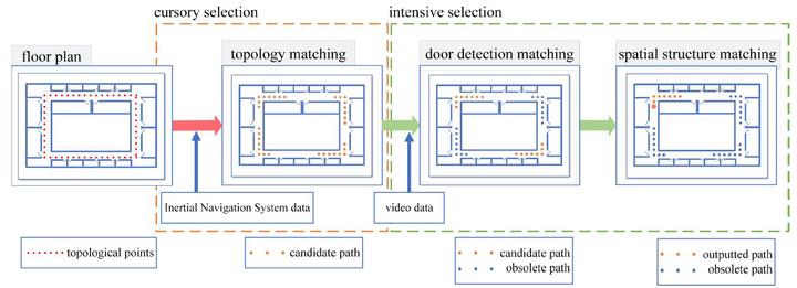
The proposed algorithm requires 2D plane map, foot-mounted inertial data, hand-held shot images, realizing a real self-contained navigation system. From the topological points in the maps, the trajectory of pedestrian can be selected via three steps: 1) cursory selection by ZUPT-aided INS generates several candidate paths; 2) door detection and matching excludes some trails further; 3) the final result is decided by a Siamese Network matching the spatial structure.